What Landscape 360 is
Landscape 360 is a special program within Landscape Advisory dedicated to public education on the issues The Landscape Group works on.
Its purpose is straightforward: decisions about energy, land, and climate finance are being made quickly and often on thin evidence, and the parties affected by them — district governments, companies, journalists, communities — rarely have access to the underlying analysis. Landscape 360 releases that analysis rather than holding it as proprietary advice.
Every piece carries the reasoning, the data, and the assumptions behind it, so a reader can follow how a conclusion was reached and disagree with it on the merits. Where a number depends on a scenario, the scenario is stated. Where the evidence is thin, that is stated too.
What it covers
The program follows the same subject matter as the Group’s advisory work, released in numbered series by theme.
Energy transition: power market reform, coal retirement and transition credits, distributed renewables, and the socio-economic implications of the shift at sub-national level. Climate crisis and decarbonization: the modeled economic cost of climate events, carbon pricing, net zero pathways, and Indonesia’s contributions under the Paris Agreement.
Nature-based and ecosystem services: deforestation and commodity value chains, forest finance, jurisdictional sourcing, peat and coastal restoration, and nature-based recovery after disaster. Geopolitics and macroeconomics where they bear directly on Indonesia’s energy and climate position.
Who it is for
The audience is anyone who has to act on these issues and is not served by either a press release or a consultancy invoice.
Government agencies and their advisors, who need the numbers behind a policy option before committing to it. Companies and investors assessing exposure and opportunity. Journalists covering energy and land use, who need a source that will show its working. Researchers, students, and civil society organizations building on the evidence base.
All output is published without charge. Where a piece was produced under a commissioned assignment, the commissioner is named and the release is agreed with them.
Fire in the Protected Areas
Indonesia's conservation estate in the 2026 season — seven points in every hundred land inside it, and ten sites carry most of them.
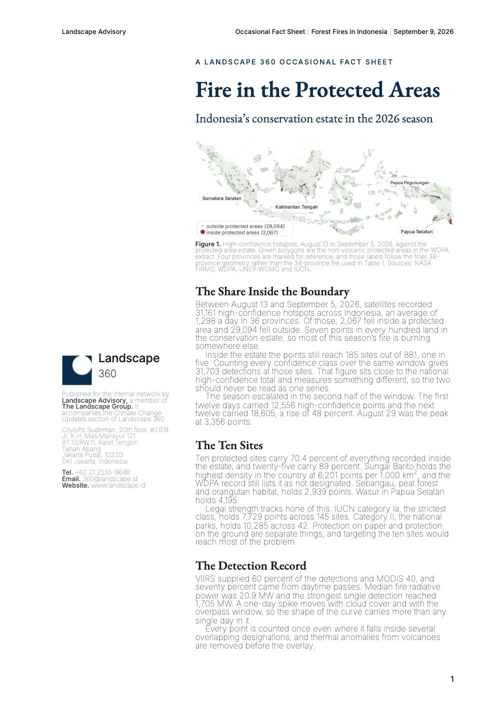
Between 13 August and 5 September 2026, satellites recorded 31,161 high-confidence hotspots across Indonesia, an average of 1,298 a day in 36 provinces. Of those, 2,067 fell inside a protected area, reaching 185 sites out of 881. The season escalated sharply in the second half of the window, rising 48 percent and peaking at 3,356 points on 29 August.
The concentration is the finding. Ten protected sites carry 70.4 percent of everything recorded inside the estate and twenty-five carry 89 percent. Legal strength tracks none of it: IUCN category Ia, the strictest class, holds 7,729 points across 145 sites. Protection on paper and protection on the ground are separate things, and targeting the ten sites would reach most of the problem.
A daily edition of the coverage that bears on the Group's work, screened and summarized. Each edition carries three highlights.
The day read against the whole archive on the topic the Group is tracking most closely — currently the 2026 forest fires in Indonesia.
The single most consequential item in the day's global entries, across energy, carbon markets, land use, finance and disclosure.
The most consequential item in the day's Indonesian entries — the power system, land allocation, and the carbon market's operating rules.